Showing posts with label US Foreign Policy. Show all posts

Saturday, March 19, 2011

Libyan NFZ: The SAM Threat

LIBYAN SAM THREAT TO UN OPERATIONS

On 17 March 2011 the UNSC voted to enforce a No-Fly Zone (NFZ) over Libya, in response to the conflict between Qaddafi's regime and separatist forces. The Libyan military operates numerous Soviet-era strategic SAM systems which represent the most likely threat to allied aircraft enforcing the NFZ. Libyan SAM systems include the S-75 (SA-2 GUIDELINE), S-125 (SA-3 GOA), and S-200 (SA-5 GAMMON). Numerous AAA, MANPADS', and tactical SAM systems are also operated, but represent a considerably reduced threat given their limited effectiveness above 20,000 feet.

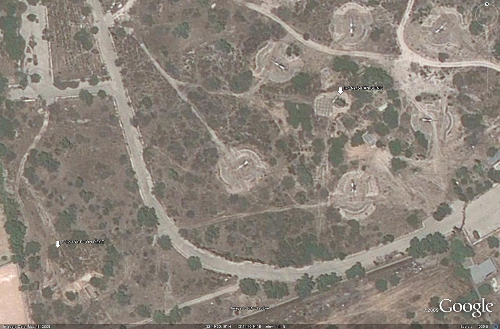
LIBYAN SAM DEPLOYMENT

The graphic presented below illustrates the pre-conflict state of Libyan strategic air defenses. Major military airfields, active EW radar sites, and operational strategic SAM coverage zones are marked. It should be noted that the graphics presented here depict identified dedicated EW facilities. Many SAM batteries possess their own organic EW elements; simply targeting the known EW facilities does not necessarily prevent the SAM force from receiving the target track data necessary to prosecute an engagement.
The majority of contested territory is along the northern coastline of Libya, shown in the graphic below. This is advantageous to any allied aircraft entering the theater of operations, as they do not have to travel deep into Libya to enforce the NFZ in support of separatist forces. Furthermore, ISR and support aircraft can be operated offshore under the protection of CAPs and naval air defense systems.
Separatist forces are concentrated along the eastern coastline of the nation from Benghazi to Tobruk and the Egyptian border. As the air defense forces in these regions are likely no longer under Qaddafi's control, the graphic below indicates the likely pro-Qaddafi SAM threat picture facing NFZ operations.
Numerous SAM garrisons and unoccupied, prepared strategic SAM sites present an opportunity for pro-Qaddafi forces to reinforce their positions prior to the start of NFZ operations. Reinforcing the strategic SAM network in this fashion will present an increased SAM threat to allied aircraft and offer increased overlapping coverage zones around key military installations. A potential reinforced pro-Qaddafi SAM network is illustrated in the graphic below.
The majority of the command and control facilities for the pro-Qaddafi regime, as well as the seat of power, are consolidated in and around the capital of Tripoli. The following two graphics depict the current operational SAM network around Tripoli, as well as a potentially reinforced network employing currently inactive positions.
ENFORCING THE NFZ

The true nature of the SAM threat to NFZ operations will become apparent when operations commence. Should allied forces choose to enforce the NFZ over the entire region, it is likely that SEAD or DEAD operations will commence against the bulk of identified pro-Qaddafi SAM sites. However, should NFZ enforcement be limited initially to protecting separatist-controlled areas in the eastern portion of the nation, it is possible that few of the pro-Qaddafi SAM sites would be targeted as they would be unable to engage allied aircraft.

The exception to the latter scenario is the S-200. The S-200 enjoys a 250 km range against cooperative targets such as ISR and support aircraft. Given that allied aircraft will likely be based out of European territories or operate from USN CVNs, heavy use of inflight refueling should be expected. Eliminating pro-Qaddafi S-200 batteries would enable allied ISR and support aircraft to operate much closer to the Libyan coastline.

Should allied forces choose to enforce the NFZ over the entire nation and consequently engage active S-75 and S-125 SAM batteries, the capability of the pro-Qaddafi SAM network could be significantly degraded with a relatively small number of sorties. The Libyan SAM inventory is constrained by the reliance on Soviet-era systems. The S-75, S-125, and S-200 are limited by the fact that each engagement radar can only prosecute a single target. S-200 batteries are often bolstered by multiple 5N62 (SQUARE PAIR) engagement radars to allow the battery to engage multiple targets, but the single-target limitation significantly reduces the effectiveness of the network as a whole. Furthermore, over-reliance on aging technology places the network at significant risk for electronic warfare interference. The US military, for example, has faced the S-75 and S-125 over Iraq and the former Yugoslavia and is well-versed on countertactics and electronic attack procedures to mitigate the threat posed by such systems. While measures may have been taken to allow the S-75 and S-125 to remain viable in Libyan service, at this point they do not present significant risks to a modern military force. That is not to suggest that they present no risk whatsoever, but rather that they are no longer considered to be high-threat systems based on their age and known technical performance.

Aerial attacks against separatist positions appear to have been curtailed in favor of ground assault and artillery bombardment. In this light, the provision of the NFZ calling for protection of civillian under threat from pro-Qaddafi forces could allow operations over regime-controlled areas. A potential military campaign could begin with strikes against SAM positions and EW facilities, followed by strikes against pro-Qaddafi forces threatening or engaged with separatist forces, particularly those near Benghazi. Given the limited number of SAM sites located in territory held by the Qaddafi regime, it is likely that the capability of the strategic SAM network to prosecute targets could be significantly curtailed within 24 hours. Cruise missiles could be employed to strike identified SAM sites, forgoing the expense of a significant SEAD or DEAD operation and allowing combat aircraft to be tasked to protect separatist forces.

CONCLUSION

With the decision to enact a NFZ over Libya, the strategic SAM network represents the most significant threat to allied aircraft tasked with its enforcement. However, due to the single-target engagement capability of Libyan S-75 and S-125 batteries, the network is far less capable than it appears at first glance. Libya negotiated for the purchase of S-300PMU-2 (SA-20B GARGOYLE) advanced SAM systems from Russia in 2010 but at this date no sale has been completed and no deliveries have been reported. Had Libya moved to upgrade its air defense network in recent years, the issue of allied aircraft enforcing a NFZ could have become a far more complicated task. Once again, a nation relying on an aged air defense network will potentially be at risk in large part because it failed to upgrade its capability. As an interesting footnote, it will be important to monitor Iran following the cessation of action against Qaddafi's regime. Perhaps the destruction of yet another aging air defense network will be the final catalyst pushing Iran to modernize it's own defenses.

SOURCES

Positional information derived from Google Earth. Range data used to create engagement zones sourced from Jane's Land-Based Air Defence. Graphics created using GIMP 2.0.

Monday, September 6, 2010

Does All of Our Intelligence Data Pass The "So What" Test?

Data relevance is critical to achieving success in the Intelligence Community (IC). Simply put, everything that we do must pass the “so what?” test, and we need to move away from creating intelligence data for intelligence’ sake. This means that every intelligence product and briefing should have a clear goal and tangible outcomes.

The unfortunate reality is that many of the IC’s efforts do not come close to passing this test. All too often, our intelligence lacks relevance or does not tangibly support a mission. The main issue is a lack of insight into goals based on achieving measurable outcomes.

The following is an example of viable intelligence that would clearly pass the “so what?” test based on tangible outcomes. Imagine that we have identified and then targeted a Taliban kidnapping ringleader, and our intel products/briefings make the argument that we have this terrorist's pattern of life and furthermore, by removing him, we will halt kidnappings in this region for a three-month period. This provides our Commander with a clear “so what?” This intelligence matters. Our Commander and staff, primarily his Operations Officer, are able to analyze the means available to them and formulate an appropriate plan to intervene. By collecting and providing the data needed to remove this leader, the key outcome is the fact that kidnappings decrease in this region. The goal of this mission was to decrease kidnappings and make this region safer, so the outcome was achieved.

From a terrain perspective, many analysts provide data about the slope, vegetation, hydrography, cover and concealment, and location of roads that could play a major role in determining the ideal location of the enemy’s SCUD launchers and associated support vehicles. The “so what?” factor is that by correctly analyzing, interpreting, combining with other intelligence disciplines, and then disseminating this data, we can predict likely SCUD locations. Similar analysis can offer Primary, Alternate, and Supplementary positions for our own Field Artillery units or ideal Drop Zones and Helicopter Landing Zones.

These examples of providing actionable intelligence seem very intuitive, and one would expect these types of efforts to be commonplace. Unfortunately, they are not all that common. One of the driving issues behind this challenge is the myriad of available data.

In 2009, unmanned aerial vehicles (UAVs) alone generated 24 years worth of video if watched continuously. In 2010, UAVs are expected to generate 30 times that amount of data—and military commanders are acknowledging the issue. According to Lt. Gen. David A. Deptula, U.S. Air Force Deputy Chief of Staff for Intelligence, Surveillance, and Reconnaissance, “We are going to find ourselves in the not-too-distant future swimming in sensors and drowning in data.” (1)

The other challenge is focusing only on relevant data. For example, many believe that the IC is only marginally relevant to the overall strategy in Afghanistan because the majority of our collection efforts and analytical prowess are focused on insurgent groups. As such, our vast intelligence apparatus still finds itself unable to answer fundamental questions about the environment in which we operate and the people we are trying to persuade. (2)

The “so what?” factor in Afghanistan is determining who the local powerbrokers are that need to be influenced, as well as how we can best engage with locals—whether they are villagers, aid workers, or Afghan soldiers—to gain the credible insights we need to help advance the mission. (2)

Now that he has been appointed the new Director of National Intelligence, one of the key challenges that retired Lt. Gen. James R. Clapper Jr. hopes to tackle is to unite the traditionally separate missions of intelligence collection and analysis and to shrink and flatten the intelligence bureaucracy. (3) Clapper has also created the position of Deputy Director for Intelligence Integration to unify the collection and analysis tasks, which is a significant step toward addressing this issue. (4)

It certainly seems that IC leaders are taking this issue very seriously, and a top-down effort could bring about true change. However, all levels of the IC must continually ask themselves “so what?” If they are unable to answer this question, their efforts may be wasting the time and resources of our troops and policymakers—and these are resources that we cannot afford to waste.

-Lt. Col. (Ret.) Marv Gordner, 2010

REFERENCES

(1) “Too Much Information: Taming the UAV Data Explosion,” Defense Industry Daily, May 16, 2010
(2) Greg Dunlap, “Fixing Intel: A Blueprint for Making Intelligence Relevant in Afghanistan,” Marine Corps Gazette, December 9, 2009
(3) Ellen Nakashima, “New Intelligence Chief Clapper Brings Sense of Humor to Serious Job,” The Washington Post, August 21, 2010
(4) Pam Benson, “Director of National Intelligence Names Deputy to Boost Collaboration,” CNN, August 20, 2010

ABOUT THE AUTHOR

The preceeding article was written for this site by Lt. Col. (Ret.) Marv Gordner, a former intelligence officer in the US Army. Mr. Gordner has twenty-one years of extensive leadership and management experience in the Department of Defense and intelligence collection field. His assignments included the 101st Airborne Division and Special Operations Forces including, 5th Special Forces, 3d Special Forces, and the Joint Special Operations Command (JSOC). He now serves as the Program Manager, Intelligence Solutions Division, for MorganFranklin.

Tuesday, May 11, 2010

The Libyan SAM Network

INTRODUCTION

Libya possesses one of the most robust air defense networks on the African continent, falling second only to Egypt in terms of coverage and operational systems. Libyan strategic SAM assets are primarily arrayed along the coastline, ostensibly defending the bulk of the Libyan population and preventing foreign incursion into Libyan airspace.

THE STRATEGIC SAM FORCE

Libyan strategic SAM assets are subordinate to the Air Defense Forces, which in turn are subordinate to the Libyan Air Force. Currently believed to be divided into five separate regional commands, the Air Defense Force operates a variety of Soviet-era equipment. The following strategic SAM systems are currently serving within the Libyan Air Defense Force: S-75 (SA-2 GUIDELINE), S-125 (SA-3 GOA), and S-200 (SA-5 GAMMON).

EW Coverage

Seventeen active and four inactive EW sites provide Libya's military with early warning radar coverage, used for SAM system target acquisition and track handoff, and GCI control of fighter units. These EW sites are located primarily along the western and eastern coastal regions, monitoring the airspace around Tripoli and Benghazi. Identified EW radars operating in Libya are predominately Soviet-era systems. The following systems have been identified in available imagery:

P-12/18 (SPOON REST)
P-14 (TALL KING)
P-35/37 (BAR LOCK)
P-80 (BACK NET)

In addition, Libya is reported to have received five Italian LPD-20 air search radars in 1983 and three Soviet 5N69 (BIG BACK) EW radars between 1984 and 1985. None of these systems have been identified in available imagery, but that does not preclude their existance.

The following image depicts the locations of identified EW radar sites in Libya:
The following image depicts a notional Libyan EW site, located near Sabha in the western portion of the nation's interior. This is representative of roughly one third of Libya's EW sites. Five sites are only fitted with P-12/18 series radars, with five being fitted with multiple radar systems. The P-12/18 sites likely serve to bolster or extend coverage, with the five sites containing multiple EW radars possibly serving as the command centers for the aforementioned regional commands.
Some strategic SAM sites contain their own organic EW elements. This allows them to perform independent target acquisition, or to accept long-range track handoff from regional EW centers. Seven SAM sites, four S-75 and three S-200, have identified EW assets. S-75 sites feature P-12/18 radars, with S-200 sites featuring P-14 radars. No S-125 sites, and the remaining S-75 and S-200 sites, contain identified EW assets, but this is likely due to the quality of available imagery rather than a lack of assets.

The following image depicts a deployed P-12/18 EW radar at an S-75 site near Tripoli:
SAM Coverage

There are currently thirty one active strategic SAM sites located in Libya. The following image depicts the locations of these sites. S-75 sites are red, S-125 sites are light blue, and S-200 sites are purple. As can be seen, the overwhelming majority of the deployed strategic SAM assets are located along the same coastal regions featuring the bulk of the EW assets.
The following image depicts the overall SAM coverage provided by the identified Libyan strategic SAM sites. Using the same color scheme applied previously, SA-2 zones are red, S-125 zones are light blue, and S-200 zones are purple.
S-75

There are currently eleven active S-75 sites inside of Libya, constituting roughly one third of the strategic SAM force. Russian sources claim that thirty nine S-75M Volkhov batteries were supplied to Libya between 1974 and 1985. Other sources suggest that the initial order of eighteen batteries supplied between 1974 and 1975 consisted of S-75 Dvina systems. S-75 batteries are deployed to protect key population centers and military facilities, predominately along the coastal region.

The following image depicts the coverage provided by Libya's active S-75 batteries:
S-125

There are currently sixteen active S-125 sites inside of Libya. Eight batteries are situated on former S-75 sites. The S-125 represents half of the deployed strategic SAM assets in the nation. Libya operates the S-125M Neva-M variant, with thirty three batteries being supplied between 1974 and 1976. As with the S-75, S-125 batteries are deployed to protect key population and military facilities, predominately along the coastal region.

The following image depicts the coverage provided by Libya's active S-125 batteries:
S-200

There are currently four active S-200 sites inside of Libya, each site being equipped with two batteries. The S-200 represents the longest-range strategic SAM system in the Libyan arsenal. The proximity of these four locations to the coastline allows them to range far out into the Mediterranean, theoretically providing a significant standoff engagement capability. Six S-200 batteries were initially supplied to Libya between 1985 and 1986, with a further five being delivered in 1988. There is some confusion as to which variant Libya operates. Russian sources refer to the system delivered as the S-200VE, but the SIPRI arms trade register refers to the system as the Angara, implying that the longer-range S-200DE was delivered.

The following image depicts the coverage provided by Libya's active S-200 batteries. A range of 300 kilometers is used, corresponding to the Angara variant.
Tactical SAM Systems

The Libyan Army operates various tactical SAM ssytems which could be called upon to provide point defense of serve as gap fillers in the overall air defense network. These systems include the 2K12 Kvadrat (SA-6 GAINFUL), 9K33 Osa (SA-8 GECKO), 9K31 Strela-1 (SA-9 GASKIN), 9K35 Strela-10 (SA-13 GOPHER), and Crotale. While the 9K33 is the most numerous system, the 2K12 represents the msot capable tactical SAM system.

Inactive Sites

There are currently thirty identified inactive strategic SAM sites located in Libya. There are fifteen S-75 sites, eleven S-125 sites, and four S-200 sites. These sites are all located within areas featuring active SAM batteries. As such, they may represent facilities available for bolstering the defenses of a given region during hostilities, drawing on equipment held in garrison, or they may represent dispersal locations for the realignment of SAM deployments over time.

To support the latter concept, it should be noted that five inactive sites, two S-75, one S-125, and two S-200, have hosted operational batteries at some point in the past. Also, three S-125 and one S-200 site currently operational were noted as being inactive at some point in the past. This suggests that there is a policy of redeployment and reorganization that occurs. Militarily this is a sound strategy, as it complicates the targeting of these facilities by a potential aggressor. While it is true that new site locations can be deduced by imagery or ELNT analysis, it adds to the workload of pre-strike planners.

The following image depicts the locations of inactive strategic SAM sites located in Libya:
Support Facilities

Eleven facilities provide logistical support for the overall strategic SAM network. Ten of these facilities are SAM garrisons housing undeployed equipment and missile reloads, with the remaining facility being a dedicated SAM training complex. Seven of the SAM garrisons are generic facilities supporting multiple systems. Based on the identification of system components in available imagery, two of the remaining SAM garrisons appear to solely support the S-75, with the remaining garrison supporting the S-125. All garrisons are located in the vicinity of prepared launch sites.

The following image depicts a combined S-75/125 garrison complex near Tripoli:
The following image depicts the Libyan SAM training complex near Misratah:
STRATEGIC SAM FORCE CAPABILITY

Libyan strategic SAM assets are arranged to provide a layered air defense zone with overlapping fields of fire. S-75 and S-125 batteries are located in close proximity to provide both redundancy and support, with the S-125 being more capable at lower altitudes than the S-75. The large number of inactive sites suggests that the force has been drawn down over time. This could be due to service life issues, equipment failure, financial reasons, or the expenditure of missile stocks.

National S-200 Coverage

The first line of defense in Libya's strategic SAM network is the S-200. Positioned along the coastline, the four active S-200 batteries provide a credible deterrent to high-RCS cooperative targets such as ISR platforms. S-200 batteries are located near Tripoli, Misratah, Surt, and Benghazi.

Coastal Coverage

Libya's S-75 and S-125 sites are concentrated primarily along the western and eastern coastlines. While the S-200 batteries are situated to provide barrier air defense of the nation's coastline, the S-75 and S-125 sites are positioned to provide point defense of assigned areas. From west to east, these sites are arrayed around Ibn Nafa airbase, Tripoli, Misratah, Benghazi, Bombah, and Adam. While contiguous coverage of the coastal region is not provided by these sites, each location is defended by no fewer than three batteries. Ibn Nafa and Bombah are defended by one S-75 and two S-125 batteries, Misratah is defended by one S-75 and three S-125 batteries, and Benghazi and Adam are defended by two S-75 and two S-125 batteries.

The following image depicts the coastal coverage of Libya's S-75 and S-125 batteries, with the locations of the S-200 batteries also marked:
Interestingly, while Surt features an active S-200 battery, all S-75 and S-125 sites in the area are currently inactive. This leaves the coastline along the Gulf of Sidra relatively undefended.

The most heavily defended city is the capitol of Tripoli. Tripoli is defended by three S-75 and four S-125 batteries, with an S-200 battery positioned south of the city. Three SAM garrisons and three EW facilities are also present in the area, as are four inactive SAM sites.

The following image depicts SAM-related facilities and coverage zones near Tripoli:
The following images depict SAM-related facilities and coverage zones near the remaining coastal areas.

Ibn Nafa Airbase
Misratah
Benghazi
Bombah
Adam
Inland Coverage

Sabha is the only inland city within Libya to have any strategic SAM defenses. Much of the Libyan interior is sparsely populated, as are the regions it borders. What then makes Sabha stand out as a location requiring SAM defenses? First, Sabha is believed to have been associated with the defunct Libyan nuclear weapons program. Second, Sabha was home to Libyan rocket development in the early 1980s, when the OTRAG rocket was tested from the Seba Oasis launch facility. There remains a significant military presence in the area, which is likely the ultimate reason for the presence of strategic SAM assets and related support facilities.

The following image depicts SAM-related facilities and coverage zones near Sebha:
Air Defense Issues

Libya's strategic SAM network is logically arrayed to defend key facilities following a point defense strategy, with long-range S-200 systems providing standoff barrier air defense along the coastal region. However, Libya's strategic SAM network has many flaws.

The main drawback of the Libyan strategic SAM network is an overreliance on aging Soviet technology. Russian manufacturers presently produce what are arguably the most advanced and capable land-based strategic SAM systems in the world. Much of their success lies in the fact that they have produced a diverse array of SAM systems with numerous variants. However, this history also presents a problem for nations relying on older technology: the rest of the world has simply passed them by. Advances in electronic warfare and ECM have made many of the older Soviet-era SAM systems obsolete in a modern air combat environment. Libya's S-75, S-125, and S-200 systems are no exception. Furthermore, despite some claims to the contrary, the Libyan strategic SAM force was generally ineffective during hostilities with the United States in the mid 1980s.

In one case, Soviet military officials deduced that the S-200 succeeded in downing three US Navy aircraft in March of 1986, based only on the perception of fragments on the radar readouts and the presence of helicopter activity in the area, the latter being attributed to CSAR efforts. The USN has never disclosed any aircraft losses during the incident, which in and of itself does not indicate that no aircraft were lost, but the other two pieces of "evidence" can easily be explained. The apparent appearance of aircraft fragments on the radar operators' screens could have been attributed to chaff dispersal or radar interference, especially if the aircraft descended below the radar's field of view. Also, helicopter activity is not limited to CSAR operations in the USN; helicopters active at the time could have been performing anti-submarine patrols, searching out and identifying surface contacts, or simply flying proiciency sorties. Whatever the case may be, the evidence does not conclusively indicate that any USN aircraft were downed by S-200s, and if the Russians or Libyans have any evidence to the contrary they have certainly never seen fit to bring it into the open.

Later in 1986, the Libyan strategic SAM network was abused during Operation ELDORADO CANYON, the US military response to Libyan support of terrorism. Lieutenant General Vladimir Yaroshenko, a former officer in the Soviet PVO SAM Troops, was assigned to analyze the poor performance of the Soviet supplied SAM systems in that operation. LTG Yaroshenko has reported his discovery that poor command and control, poor radar coverage, and a lack of appreciation for American anti-radar weapons and tactics precluded effective target engagement. One interesting fact which he mentions is that the S-75 batteries had a minimum engagement altitude of 100 meters, corresponding to the S-75M Volkhov system as mentioned previously. He also confirms that only one US aircraft, an F-111 shot down by AAA fire, was lost, despite Venikian levels of propaganda claiming otherwise at the time.

Part of the current problem stems from international sanctions placed on Libya during the 1980s which effectively stifled any serious chances of upgrading or replacing obsolete systems. The rest of the problem lies in the systems themselves. All three strategic SAM types operated by Libya have been thoroughly exploited by Western intelligence agencies, and many Western nations have faced these same systems in combat at various times, allowing for continued refinement of ECM systems designed to defeat these weapons electronically. Also, no strategic SAM system operated by Libya possesses a multi-target engagement capability. The only SAM sites representing a threat to multiple aircraft are the S-200 locations, as they possess multiple 5N62 (SQUARE PAIR) engagement radars. As such, even though Libyan strategic SAM sites are arrayed to provide overlapping fields of fire while defending a given area, the relatively small number of sites represents a threat to only a small number of targets. As a result, the overall network is easily susceptible to oversaturation.

The second drawback to Libya's strategic SAM network is one of layout. If it is accepted that older Soviet-era systems may still be reliable against regional aggressors lacking modern, sophisticated EW or ECM suites, the system still has a significant number of gaps that could be exploited. The S-200 represents the only significant over water threat, but is constrained by having a minimum engagement altitude of 300 meters. Any terrain-hugging aircraft or cruise missiles would easily be able to exploit this weakness to approach the Libyan coastline. Once the coastline has been reached, the most obvious point of ingress would be the area adjacent to the Gulf of Sidra, which is devoid of deployed strategic SAM assets. Furthermore, as evidenced in the image seen previously, there are gaps between areas covered by S-75 and S-125 batteries which could also be exploited. This does not of course take into account the presence or performance of interceptors, AAA, or tactical SAM units, as these systems are outside the scope of this analysis.

CONCLUSION

At the end of the day, the Libyan strategic SAM network requires a massive infusion of new technology to remain viable in the twenty first century. It was not capable of repelling an attack over twenty years ago, and there is no reason to suspect that it will be capable of such action today. Libya is reportedly negotiating for the purchase of advanced S-300PMU-2 (SA-20B GARGOYLE) SAM systems from Russia, which would go a long way towards modernizing the network and restoring its effectiveness. Colonel al-Gaddafi has made great strides in bringing Libya back into the community of nations, and deserves a large amount of praise for doing so, but that should not lessen the Libyan government's desire or responsibility to provide adequate defense for its citizens.

SOURCES

-The aforementioned data is based on analysis of the available open-source satellite imagery of Libya and may therefore not represent the entire air defense network.

-Satellite imagery provided courtesy of Google Earth

SIPRI
The North African Military Balance: Force Developments in the Maghreb (PDF File)
The OTRAG rocket
Jane's Land-based Air Defence, various editions
SAMs of the PVO, Mikhail Pervov, 2001
Fakel's Missiles, Vladimir Korovin, 2003

Saturday, May 30, 2009

Nuclear Korea

INTRODUCTION

On the 25th of May, 2009, the Democratic People's Republic of Korea (DPRK) conducted its second nuclear weapons test. Once again, the DPRK has become an area of focus for intelligence analysts and politicians as the next course of action for the West is determined. While it remains to be seen whether or not tensions between the DPRK, its southern neighbor, and the rest of the world will be mitigated, one fact remains: the DPRK is developing a nuclear arsenal.

NUCLEAR TESTING

The DPRK has detonated two nuclear devices in the past three years. The first test took place in October of 2006, with the second taking place in May of 2009. Seismic monitoring has provided analysts with a general location of both test events, along with a rough determination of the yield of both tests. The first test seems to have been a sub-kiloton event, with the second test falling in the 1-3 kiloton range. The test location is roughly 65 kilometers northwest of the Musudan-Ri missile test complex, in the isolated northeastern sector of the DPRK.

THE TEST SITE

The DPRK's nuclear test site consists of multiple areas. The isolated location is ideal for this type of testing; there is no civillian presence to speak of, and the terrain allows for UGFs to be employed at will to protect and mask sensitive activity. The bulk of the test area consists of three likely test locations, five unidentified locations, and a rail transfer point located south of Sumunnae, representing the only significant source of transportation into the area.

The locations of the identified facilities and areas in the DPRK's nuclear test area can be seen in the image below. Unidentified facilities are marked as red buildings.
Two of the possible test locations are similar, with the third site being of a wholly different configuration. Of the two similar sites, the northern site is commonly associated with the DPRK's nuclear testing. Whether this is due to intelligence sources leaking information or due to imagery interpretation, it is interesting to note that the southern site has escaped mention, as has the central site. Moreover, Globalsecurity offers before and after imagery of the northern site captured at the time of the 2006 nuclear test. While the imagery is not the highest quality, it should be pointed out that there does not appear to be any significant difference or change in activity at the northern site in either image. This begs the question: was this the actual site of the October 2006 test?

After the 2009 test event, the CTBTO provided coordinate data for the presumed test events of 2006 and 2009, along with probability ellipses indicating the area around the theorized detonation sites where the event was likely located. All three of the identified facilities in the test area fall within the boundaries of both the 2006 and 2009 probability ellipses.

While there is no firm evidence to suggest which site was the "host" to which event, some conclusions may be drawn. It is likely that at least one event took place at the northern site, given that all of the coordinates released by various agencies such as the USGS and the CTBTO for the epicenters of the 2006 and 2009 events are arrayed roughly in an east-west line just north of the northern site. This suggests that at least one, and perhaps both, of the test events took place at the northern site. The central site is not as expansive as the other facilities, and features an antenna farm of some sort, suggesting that it may represent a monitoring station for the two other facilities. The devices seen mounted atop the masts to the north of the facility may be atmospheric sampling devices meant to track the unintended release of radiation from the underground tests.

Details of the northern, central, and southern sites can be seen in the images below. The first image depicts the north site. A possible security checkpoint for entry into the test area can be seen, as well as the likely location of the test shaft itself.
Next, the central site can be seen. This site contains fewer structures than the north or south sites. In fact, the facilities on the western edge of the main area appear to possibly be in disrepair, suggesting that this may have been an existing facility partially converted to use for monitoring the nuclear testing grounds. To the north, the possible sensor masts can clearly be seen.
Finally, the southern site is depicted. Notice the similar layout to the northern site, with the buildings in the main area of the facility organized in a general "U" shape. There is also a possible security checkpoint, and a facility which may be housing the opening to the vertical test shaft. More likely, however, would be positioning the entrance to a vertical or horizontal shaft inside the main facility itself, given that it is situated in a valley between two ridges.
The remaining four unidentified facilities in the area likely perform administrative and support functions for the test range. One such facility, seen in the image below, contains a helipad and apparent housing structures.
The three remaining facilities may be abandoned or unoccupied military garrisons (the site was imaged in February of 2005), or further housing and support areas for nuclear technicians manning the site during a test cycle. The lack of activity at these locations in the available imagery suggests that the site may only be manned during a test period, and also raises a significant question: where did the bomb come from?

There are numerous UGFs in the area, a helipad, and a rail transfer point to the south. This suggests that range security and transport may be supported by helicopter, and that significant amounts of material and personnel arrive by rail, perhaps after arriving in the region by air. The UGFs and various unidentified facilities are the dark horses of the facility. It is possible that the components were delivered individually and then assembled on-site for a test. It is also possible that there is a nuclear weapons plant buried within one of the UGFs producing the weapons after nuclear material is delivered. A final option, one which has no real supporting evidence but which should nevertheless be considered, is that there is a facility in the region, likely inside of an UGF, that produces both the fissile material and the weapons. Enrichment facilities at Yongbyon would seem to refute this idea, but it does make for an interesting theory: while the world is distracted by the goings-on at Yongbyon, the DPRK quietly produces and tests nuclear weapons at a much more remote and lesser-known facility.

NUCLEAR GOALS

Many analysts have assumed that the DPRK is working towards a nuclear capability and has not as of yet fielded a weaponized bomb. There are two holes in this logic which should be pointed out immediately. Bear in mind that this is speculation, and should not necessarily be taken as pure fact, but rather a logical line of thought given the information at hand.

Firstly, a small detonation is a small detonation, not necessarily a fizzle or test failure. Current estimates indicate that the 2009 event was the result of a device no larger than three kilotons detonating underground. Rather than assuming that this is a step towards a multi-kiloton, or even megaton class nuclear or thermonuclear device, the possibility that the test was a complete success and the weapon performed as designed should not be overlooked. For that matter, the previous test in 2006 may have been a complete success as well, either testing a small-scale nuclear device or validating the performance of the components to be used for a later test.

With regard to the possibility of a small-scale nuclear weapon having been developed successfully, it is known that an armed conflict on the peninsula would result in the DPRK employing a large number of special operations forces. Small devices would be ideal weapons to smuggle into the Repiblic of Korea and detonate in advantageous locations. A small device detonating on the Han river in Seoul, for example, would not only destroy many of the bridges crossing the river, but would likely incite a mass panic, without obliterating a sizeable portion of the city itself. The resulting exodus of civillians, seeking shelter from future attacks or medical care for exposure to radiation, has the potential to interfere with the movement and resupply of military forces in the region. Small warheads would also be ideal for delivery by submarine or missile to targets such as air bases close to the coastline, and could be detonated inside the major port facilities to further complicate the ROK's resupply and civillian evacuation operations. From an asymmetric aspect, they could also be used after an outbreak of hostilities to environmentally cripple fishing grounds in the area which are important for both the ROK and Japan.

The second of the aforementioned holes in logic is that current analysis seems to be focusing on a nuclear-armed ballistic missile representing the end result of the DPRK's nuclear weapons program. As demonstrated previously, this may not necessarily be the case. The standard explanation given is that the DPRK has designs on fielding a nuclear-armed ICBM capable of striking the United States. Testing a weapon and miniaturizing the warhead to fit atop an ICBM takes time. However, this assumes that the second test was another trial, and does not allow for the possibility that the device which detonated was a weapons-ready device. If that were to be the case, then it would be likely that the intended delivery vehicle is not in fact an ICBM.

If DPRK nuclear warheads do not progress much further in yield, they will not have much value atop the nations's largely inaccurate ballistic missiles over intercontinental ranges. This would make aerial delivery or delivery by other means far more likely as they can impart a greater degree of accuracy. Where the weapons would be valuable in terms of missile delivery would be as "terror weapons" meant to be fired at the ROK or Japan. In this capacity the accuracy of the delivery systems would be less important given the large metropolitan and industrial areas in each nation which would be far easier to target. Also, firing a small yield weapon into the ROK to cause panic among the populace as described previously would not result in a release of radiation on the scale found in detonating a much larger weapon. That would almost make it more logical for the DPRK to pursue smaller yield weapons as they could then be employed in select areas without causing a significant degree of ill effects for the DPRK's own military forces to contend with. Alternatively these small weapons could be deployed in artillery shells or battlefield rockets to pulverize US and ROK positions along the DMZ before an advance into the ROK.

However, a limited number of nuclear warheads, large or small yield, are still not logically destined to be fitted to ballistic missiles targeting facilities in or outside the Korean theater. The DPRK's leaders may be paranoid and misguided, but they are not stupid. The United States is fielding numerous ballistic-missile defense systems and has multiple PAC-3 batteries in theater. Japan is also fielding the PAC-3, and the ROK is beginning to field the Patriot system as well, albeit in the PAC-2 form. AEGIS ABM-tasked vessels could also be placed in-theater if needed. This would make relying on ballistic missiles as the delivery system for nuclear warheads a questionable proposition as there is no guarantee that the nuclear-armed missiles would reach their targets. That is not an acceptable proposition for such an important national asset, of which there would only be a limited quantity. In that respect, the asymmetric, naval, or airborne delivery methods begin to seem far more plausible, and more logical from the standpoint of the DPRK. Airborne delivery would not necessarily require any miniaturization of a weapon, making it seem like a decent enough solution, but many of the same air defenses which would be used to intercept ballistic missiles would also be able to target hostile aircraft in conjunction with allied fighters, making airborne delivery a dubious proposition as well. At the end of the day, unless a large number of warheads are fielded to mount atop ballistic missiles and the loss of a percentage is accepted, the most likely uses would seem to be naval or asymmetric.

There is still value to testing a nuclear-capable ballistic missile, even if a large scale deployment is not planned. This would force the US, the ROK, and Japan to divert more attention and resources to missile defense, potentially at the expense of other forces in-theater. Ergo, small-yield weapons testing and ballistic missile trials may not indicate that the DPRK is intending to operationally mate missiles and warheads to a significant degree.

FUTURE EFFORTS

The next question that must be answered is the future direction of the DPRK's nuclear weapons program. It will be important to study the results of any future nuclear test events to answer some of these questions.

Further tests resulting in a yield in the same range seen in the 2009 test will indicate that this is likely the design yield of the weapon. Contrarily, testing of weapons with increasing yield will indicate that the DPRK has its sights set on large yield weapons, and perhaps on thermonuclear weapons. Future nuclear test events will also aid analysts in determining the potential uses for such a weapon. Large yield weapons would have the ability to strike hardened facilities using less-accurate delivery systems, but small yield weapons would have to be accurately delivered and may only have limited use until a time when the DPRK has fielded a ballistic missile with hard-target kill levels of accuracy. Also, an expanded test program with shorter intervals between events will likely indicate that the DPRK has neared deployment of an operational weapon. However, a lack of test events does not necessarily indicate that weapons are not being deployed; if, as theorized previously, the current test met the DPRK's goals, then future testing may not be required until such a time when a larger yield weapon is desired.

Missile testing and training operations will also provide insight into whether nuclear warheads are being developed or deployed. Chemical or biological weapons are more likely to be used given their comparative cheapness and the belief that the DPRK maintains a large stockpile of one or both of those weapons. As long as CBW handling operations are detected in missile units without a significant change in procedure, it can be assessed with a degree of accuracy that nuclear weapons are not present.

A final option to consider for the future is another weapon system that has been rendered partially ineffective by recent defensive systems testing by the West: a FOBS. The DPRK's continued efforts to develop the Taepo-dong 2 SLV/ICBM is potentially indicative of a desire to have a space launch capability. After the most recent test the DPRK declared that a satellite had been orbited, a point which Western analysts dispute. Nevertheless, as a nuclear-tipped TD-2 is a paper threat until the DPRK produces a warhead of significant size to overcome the inherent inaccuracy of the delivery vehicle and develops penetration aids to defeat any American ABM systems, if a satellite launch capability can be developed and demonstrated, a FOBS would be an interesting avenue to pursue.

CONCLUSION

It can be stated with certainty that the DPRK is developing a nuclear weapons capability. How far along the program is, how many weapons may be available, and the intended and actual yields of the developed systems are up for debate. But at the end of the day, it would seem that the world is going to have to make room for another member of the Nuclear Club. How the West approaches and deals with the DPRK will have a significant impact on other nations wishing to acquire the same capability, providing them with an idea of how far the West will go to get its way. In this light, the DPRK's nuclear program, should it reach operational status, may be an impetus for Iran to fully develop a similar capability. And as a final note, the effect of a nuclear DPRK in the Korean theater may have much more ominous implications; could this be the final straw which forces Japan to shake off its self-imposed shackles and become a nuclear and offensive power in its own right?

ADDITIONAL DISCUSSION

Feel free to discuss the content of this article at the IMINT & Analysis Forum in the discussion thread found here.

SOURCES

-Satellite imagery provided courtesy of Google Earth

HYDESim
CTBTO on the DPRK's Nuclear Tests
The ROK's Patriots
DPRK Nuke Test
ISIS Online

Tuesday, May 5, 2009

Taiwan's SAM Network

INTRODUCTION

The island of Taiwan sits less than 200 kilometers from the coast of the People's Republic of China. Faced with a potential threat consisting of over a thousand ballistic missiles and swarms of strike fighters, Taiwan's strategic SAM network is a significant element of the island's defense.

2/71 AND NIKE

Strategic air defense of Taiwan began in the 1950's during a highly classified US military deployment to the island. Soldiers and equipment from Fort Bliss deployed to Taiwan as the 2nd Battalion, 71st Artillery, forming a four battery MIM-14 Nike-Hercules SAM network along the northwestern edge of the island. The deployment of US Army personnel only lasted for a year, but the seeds were sown for Taiwan's strategic air defense network. Not only did Taiwan retain the four Nike-Hercules batteries previously operated by the US Army, but a further four batteries had been procured at some point before the mid 1970s. These systems represented the first significant strategic air defense network to appear in the cross-strait conflict zone, and were retired in 1996.

GENERAL LAYOUT

Taiwan's present-day strategic air defenses are oriented logically with respect to the perceived primary threat to the nation's security: the People's Republic of China. The bulk of the air defense assets are located on the northern and western sides of the island, with their sensors illuminating the cross-strait environment to monitor for any unauthorized inbound traffic. Air surveillance is provided by eleven EW facilities, and engagements are prosecuted by twenty two fixed missile batteries, occupied by HAWK, Patriot, and Tien Kung SAM systems. These systems have engagement ranges of 40 kilometers, 160 kilometers, and 200 kilometers, respectively. A further twenty two Skyguard facilities are located to provide close-in defense of key population centers and military facilities, some of which are equipped with 18 kilometer range RIM-7M Sparrow missiles.

The following image depicts the general layout of Taiwan's strategic air defense network. EW sites are marked with blue diamonds, the CSIST Missile Test Facility is marked with a brown square, and SAM sites are marked as follows:

HAWK: Orange triangle
Patriot: Yellow triangle
Tien Kung: Red triangle
Sparrow: Green triangle
Inactive: White triangle
HAWK

Taiwan acquired the MIM-23 HAWK SAM system in the 1960s. Thirteen prepared HAWK sites are currently occupied by active batteries. One battery is located offshore in the Penghu island group. The remaining sites wrap around the western coast of Taiwan at intervals of roughly 65 kilometers. Taipei and Kaohsiung, Taiwan's largest population centers, are defended by three sites and two sites respectively, with closer spacing to provide a greater degree of overlap in their fields of fire. Three sites are present on the eastern shore of the island, situated to defend the three main population centers in that region.

The locations and coverage of Taiwan's HAWK batteries can be seen in the image below:
TIEN KUNG

CSIST began to develop the Tien Kung SAM system in the early 1980s, envisioning a replacement for Taiwan's aging HAWK batteries. The system has been produced and deployed in two variants, the Tien Kung I (TK-I) and the improved Tien Kung II (TK-II). An ATBM Tien Kung III is in development. The TK-I was originally fielded in both static and mobile variants, with the TK-II only being deployed in a static variant. In 2006 it was announced that the TK-I was being retired and replaced by the TK-II. It was not specified if the TK-Is were only being replaced in the static launchers, or if the mobile TK-Is would be withdrawn as well.

The TK-I was deployed on a trial basis in 1989 and declared fully operational in 1993. The TK-II was deployed in 1996. The TK-I had an engagement range of 100 kilometers, with the TK-II having a range of 200 kilometers and adding an active radar terminal homing seeker. The TK-I, in contrast, relied on SARH for terminal homing. Both systems receive target acquisition and midcourse guidance support from an ADAR-1 Chang Bei LPAR. In the TK-I, a CS/MPG-25 continuous wave illuminator provides the necessary target illumination during terminal homing for the SARH guidance method.

The static SAM systems are deployed in silo launchers at six fixed sites, two sites being located offshore. One is located in the Penghu island group, and the other is located in the Dongyin island group. These silo launch facilities are unique in the field of air defense; no other active land-based SAM system in the world uses a silo-based launch method. Each silo launch complex consists of two separate areas: a silo launch facility and a radar facility.

The silo launch facility consists primarily of five underground launch complexes. These complexes each house four four-round vertical launch cells for TK-I or TK-II missiles, for a total of 80 missiles per complex. Two CS/MPG-25 CW illuminators are present at each complex.

The image below depicts a silo launch facility constructed on the grounds of a former Nike Hercules launch site.
Mobile TK-I systems may be deployed at these fixed launch facilities in some capacity, either to augment the silo-mounted TK-IIs or simply to utilize the garrison facilities before being field deployed as required. It is possible that mobile ADAR-1 LPARs could also be employed at silo launch facilities to increase the target engagement capacity of a single battery. Whatever the case, CS/MPG-25 illuminators were still emplaced at static launch complexes imaged at various points in 2006, implying that TK-Is were possibly still present in some capacity and had at the very least not yet been fully removed from silo launchers.

The radar facility consists of a fixed, hardened ADAR-1 LPAR. One radar facility is attached to each silo launch facility. The two facilities are separated by a distance of between one and four kilometers and are treated as a single complex. Separating the complexes allows for the hardened radars to be built into bunkers which are at a higher elevation than the launch facility. This allows the radars to have a less cluttered field of view without employing far more vulnerable mast-mounted antennas, and to mitigate the effects of the radar horizon on the system's engagement envelope.

The image below depicts an ADAR-1 radar facility:
Both of the above images are interesting in that they are both censored in the default Google Earth imagery set. They can only be accessed through the historical imagery feature. Various Tien Kung associated facilities can only be viewed in this fashion.

While the Tien Kung SAM system has a maximum range of 200 kilometers with the latest TK-II variant, the engagement zones of these fixed launch sites are oriented in specific directions. The fixed ADAR-1 LPAR has a 120 degree field of view in azimuth, able to scan 60 degrees to the left and right of center. This determines the engagement zone available to a missile fired from the associated fixed launch site. Mobile radars could theoretically be employed to increase the coverage zones, but it is not known if the TK-I's mobile ADAR-1 sets are compatible with the silo-launched TK-II missile. It would seem likely that they are, or could be with minimal modification, given that the hardened ADAR-1 radars are still employed by the TK-II system.

The locations and engagement zones of the five southern fixed launch sites can be seen in the image below. The zones are oriented to match the likely fields of view of the hardened ADAR-1 LPARs and correspond to the 200 kilometer TK-II system. A TK-I fired by a fixed launch site would engage a target within the same zone, but only to half the range. The Dongyin island group Tien Kung site is not included as the LPAR field of view cannot be determined due to a lack of high-resolution imagery.
PATRIOT

In 1993 Taiwan purchased three MIM-104 Patriot SAM batteries from the United States, receiving PAC-2 standard weapons. Taiwan's three Patriot batteries became operational in 1998 and were deployed at prepared sites near Taipei for capital area air defense, focusing on an ATBM role. The AN/MPQ-65 radar, when emplaced, has a field of view of 120 degrees in azimuth. The radar is not rotating for full 360 degree coverage, rather it is aligned in the direction of a potential threat axis when deployed. While the radars can be repositioned and realigned when needed, historical imagery indicates that these three batteries have remained aligned in the same general direction since at least 2000.

The locations and coverage zones of Taiwan's Patriot batteries, as currently imaged, can be seen below:
SKYGUARD-SPARROW

The final component of Taiwan's strategic air defense network are the close-in, point defense RIM-7M Sparrow SAM systems integrated with Skyguard batteries. The locations of identified Skyguard installations, along with the coresponding engagement zones for the Sparrow-equipped batteries, can be seen in the image below:
OVERALL COVERAGE

The main issue facing Taiwan is numerical. With an estimated 1300-1500 ballistic missiles and hundreds of strike aircraft targeting the island from the People's Republic of China, it would appear that Taiwan simply cannot afford to procure and deploy enough land-based SAM systems to guarantee clear skies in a time of crisis. That is not entirely true, however, given a complete understanding of a potential conflict. The People's Republic of China wishes to reintegrate Taiwan with the mainland, not acquire a new bombed-out target range for its military forces. Logically speaking, while certain targets are likely to be struck during a military engagement, and likely struck multiple times to increase the chances of oversaturating the air and missile defenses, it is not likely that the PLA will simply bombard the island into submission. Simply speaking, that would completely defeat the point of any military confrontation designed to reintegrate Taiwan. Therefore, when faced with a numerically superior force desiring to eliminate key military facilities rather than to obliterate the entire island, the logical approach would be to employ strategic SAM assets and air interceptors in an integrated air defense system (IADS).

In an integrated warfighting environment, TK-II SAMs could be employed beyond a certain range to thin out inbound formations, while air interceptors remain on station to combat the remaining inbound aircraft. Any cruise missiles or aircraft penetrating the combat air patrol zones could be engaged by HAWK SAMs, as well as SHORAD systems such as Skyguard. Naval SAM systems could also be employed offshore to provide further assistance in thinning out any inbound aggressors. While this strategy would likely still result in a number of successful strikes, it represents a logical, organized use of the assets at hand when faced with a numerically superior threat.

Taken as a whole, the strategic SAM network on Taiwan is well organized. Engagement zones have a significant degree of overlap, allowing targets to be shared by multiple systems, and HAWK batteries are logically deployed as both a closer-in defensive line and a gap filler to eliminate holes in the network created by the azimuth limitations of the hardened ADAR-1 LPAR facilities.

The overall coverage zones of Taiwan's strategic SAM systems can be seen in the image below. As mentioned previously, the Dongyin island group Tien Kung site is not illustrated.
It should be pointed out that the eastern side of the island is relatively undefended in terms of SAM coverage. This should not necessarily be seen as a weakness in the overall network, as the bulk of the military and political targets likely to be struck during a conflict are not in this region.

It has been reported that Taiwan possesses eighteen or twenty HAWK batteries, but there have only been thirteen HAWK sites identified. The remaining batteries are likely held in reserve for attrition replacement and training purposes. They are also potentially available to be field deployed during a crisis to reinforce air defenses in certain sectors. Likewise, existing HAWK batteries could be removed from their fixed locations and deployed to field firing positions, as could Patriot or extant mobile TK-I units.

There is evidence suggesting that plans may exist for redeploying Patriot and/or TK-I batteries during a crisis. The following image represents a Patriot or TK-I mobile SAM site constructed on the grounds of a former MIM-14 battery. The image was captured in late 2004, when Taiwan only possessed three PAC-2 Patriot batteries. These batteries were all intended primarily for ATBM defense of Taipei, as previously mentioned, and were already sited in that region. Ergo, this unoccupied facility was likely not intended to house a permanent Patriot battery, as the only Patriot batteries in Taiwan were already positioned according to their intended role. It is, of course, possible that this facility was home to a mobile TK-I battery which has since been deactivated, but that does not preclude the site from being used as a deployment site in the future.
One oddity that stands out when analyzing the coverage zones of Taiwan's strategic SAM network is the presence of a corridor north of the Penghu island group, heading roughly north towards the Chinese mainland, which is only defended by a single Tien Kung fixed launch site. This is unusual because care has apparently been taken to ensure a degree of overlap in most of the network. This corridor could simply be an aberration of geography meant to be filled by a naval SAM system, it could be a purposely less-defended corridor for civillian traffic meant to be filled by a mobile TK-I battery in the Penghu islands, or it could represent a "safe zone" for outbound strike aircraft. The latter example is noteworthy; as the corridor passes over the Chinese mainland, it is flanked on either side by a Chinese S-300PMU-1 (SA-20A GARGOYLE) SAM battery. This could have been identified by the People's Republic as a potential ingress route for Taiwanese strike aircraft desiring to enter the Chinese mainland and attack ballistic missile launch positions and garrisons. The PLA's DF-11A garrisons at Xianyou and Yong An, along with the DF-15 garrison at Nanping, would likely be within reach of such a strike package. This is, however, pure speculation, but does draw attention to the types of data which could potentially be revealed by analyzing an air defense network.

FUTURE PROSPECTS

In the future, Taiwan's goal is to greatly increase the effectiveness of its strategic air defense network against ballistic missiles. To that end, CSIST has been developing the TK-III, an ATBM off-shoot of the TK-II. The Taiwanese government has also been in negotiations with the United States to procure PAC-3 series Patriots with their associated ERINT ATBMs.

The ERINT ATBM has a range of 20 kilometers against a ballistic target, and is designed as a hit-to-kill weapon with very high accuracy. An enhanced variant is being developed which would increase the ATBM range to 45 kilometers. In January of 2009 it was reported that Taiwan had received approval for a contract with Raytheon to upgrade the three existing PAC-2 batteries to PAC-3 standard, enabling them to support the ERINT missile. Taiwan is still negotiating the sale of 330 ERINT missiles as well as four AN/MPQ-65 radars and other Patriot components to deploy three or four additional Patriot batteries.

The footprint of the Taipei PAC-2 sites, when upgraded and equipped with PAC-3 ERINT weapons in an ATBM capacity, can be seen in the image below:
Taiwan is also developing a new SHORAD system based on the Tien Chien II (TC-2) BVR AAM, to be integrated with the Antelope SHORAD system as a Skyguard replacement.

STEALTH OFFENSE

No discussion involving the TK-II SAM system would be complete without a brief mention of the Tien Chi surface-to-surface missile derivative. This weapon is a 320 kilometer range system fired from static TK-II launch sites. It is believed that the system is deployed in two locations, and that one of them is the Tien Kung facility in the Dongyin islands. The other is likely the Tien Kung facility in the Penghu islands, as offshore basing does allow for greater inland reach of mainland China.

The following image depicts some of the potential targets for the Tien Chi missiles, assuming that they are based at the two aforementioned locations. The missile locations and their associated ranges are indicated in white. Do note that not only is one of China's OTH-SW systems within range of the Dongyin site, but that it can also reach the two S-300PMU-1 batteries mentioned previously. The main drawback of the system, however, is short range; the image depicts the PLA's 52nd Division ballistic missile units, and only two of them are within range of the Tien Chi system. Given the sheer number of Chinese ballistic missiles available in the theater, it is more likely that the Tien Chi is intended for high-value targets such as the OTH-SW system.
CONCLUSION

Taiwan's strategic SAM network has been arranged logically given the potential threat it has been designed to counter. As more ATBM systems are developed, the network will continue to evolve into a more modern, capable system, in much the same manner that the network of Taiwan's cross-strait rival has evolved. While the SAM network is not capable of deterring a massed, large scale attack, it is modern and credible enough to act as a potential deterrent against small-scale incursions or attacks, and therefore is a stabilizing force in the region.

GOOGLE EARTH PLACEMARK DATA

A Google Earth file containing the placemarks used in the generation of this article can be downloaded here.

ADDITIONAL DISCUSSION

Feel free to discuss the content of this article at the IMINT & Analysis Forum in the discussion thread found here.

SOURCES

-Special thanks to IMINT & Analysis forum members Planeman and BryanC for acting as sounding boards and discussion partners during the creation of this article

-Satellite imagery provided courtesy of Google Earth

-Jane's Land-based Air Defence, various editions

2nd Missile battalion, 71st Artillery (Taiwan) Association
Taiwan: Missile Profile
Taiwan to Upgrade to Tien Kung-2 SAM
Taiwan switches from Tien Kung I to Tien Kung II
Tien Chi
The AN/MPQ-65
Raytheon welcomes PAC-3 deal
FMS: Taiwan Seeks 330 Patriot PAC-3 Missiles and Four MPQ-65 Radar Sets

Thursday, February 5, 2009

Sunday, December 21, 2008

The Avenue To Peace Runs Through...Piracy?

PEACE THROUGH PIRACY?

Right, I know I don't go off into the political side of things that often, but bear with me on this one.

Russia. The Ukraine. China. America. Iran.

What do all of these nations have in common?

The answer: as of today, all of them have dispatched warships to combat piracy off the coast of Somalia. Some to interdict pirates, some merely to protect their own interests. The interesting issue in all of this is that most of these nations are not exceptionally fond of each other. Russia and the Ukraine are having problems. America and Iran have not had a friendly relationship since 1979. And China? The US political machine wants everyone to believe that they are the new Red Menace. Makes for good military sales figures, but not much else from a logical standpoint. But I digress.

Normally, when potentially belligerent nations are operating military hardware in close proximity to one another, bad things can happen. There is the potential for misidentification of intentions and an outbreak of hostilities. Which, plainly, is not really good for anyone.

That's why the issue of piracy off the coast of Somalia represents a very interesting political avenue that should be exploited by the US government. This is an opportunity to reach out to all parties involved and establish a joint working group for combating the piracy issue. This may in turn help to break down some barriers in dealing with nations like Iran or Russia. A common goal can often be a good stepping stone to further cooperation and potentially improved relations down the line.

Sending a few warships into the Indian Ocean to eradicate pirate vessels is not going to result in the establishment of an American embassy in Tehran or the elimination of Russian opposition to all things NATO or missile defense. But in the long term establishing a good working relationship in this issue with the nations involved could at the very least break the ice and open doors previously locked should the need arise for further military or diplomatic dealings in the future. And if taking out a few pirate ships attacking Iranian cargo vessels or harassing Russian freighters means we are on the road to better relations with those nations, it would be in the best interests of the US government to open its arms to those nations in the spirit of joint cooperation.

Besides, five nations working together to obliterate pirate boats and shore positions would surely be far more effective than each nation plowing across the sea lanes looking for trouble on their own.